

Land of Fire and Ice:
Exploring Sullivan Swamp, a Southern Appalachian Shrub Bog
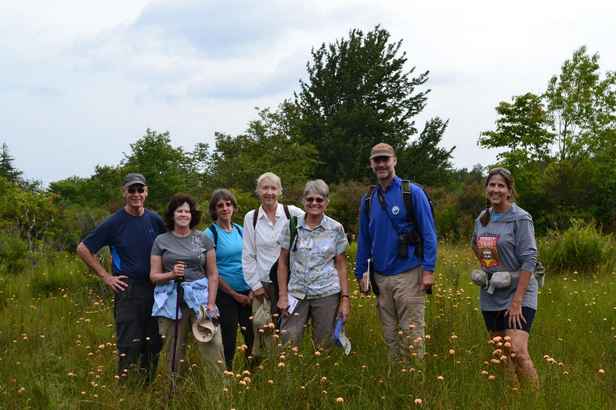
On the weekend of August 15, 2015, Devin Floyd, BRDC Co-Founder, took a group of explorers to Sullivan Swamp in Grayson Highlands State Park. On this hike participants explored one of Virginia's rarest ecological treasures. The ecosystem visited is classified as a southern Appalachian shrub bog, of which there are only about 30 on the planet. There are at least three occurrences of this ecosystem in the Mount Rogers area, and these bogs are the largest of those documented to date, covering about 8-10 acres each. This journey through time began with a brief introduction at the Massey Gap parking lot. From there participants traversed the rugged grassy shrub meadows and balds to the north, up the slopes to Wilburn Ridge, and eventually down into a giant bowl-shaped swale that harbors the bog.
The geology of this mountain is a primary factor that has shaped the plant and animal communities that live upon it. It is the volcanic rock, known as rhyolite, that is resistant enough to hold the mountain high through eons of weathering. It is rhyolite that is homogenous enough to weather to a smooth round top, resulting in the globally rare balds and bogs that haunt Grayson Highlands. Because the rocks hold the mountain up, and because of their shape, form, and mineral content, unique ecosystems reside there. Participants were transported back in time to experience the origins of this rock and imagine what the landscape may have looked like when this rock was formed.
The group stood atop a ridge above the bog as Devin relayed 750 million years of geologic change in a 15 minute story, followed by 5 minutes of Q-n-A. Here are some highlights:

Fire. 750 million years ago, Virginia was turned 90 degrees clockwise from its present position. It also rested far south of the equator. We would have been in the center of a giant super continent scientists refer to as “Rodinia”. All the continents were crammed together into one huge landmass, and they had remained so for nearly 400 million years. But, 750 million years ago, the time had come for those continents to begin moving away from each other again. When this happened, great rift valleys opened up – the valley floor dropped a mile in places – albeit slowly, maybe a couple inches per year. Southwest Virginia, and the Mount Rogers area, were at the location of one of these valley openings, and in the valley floor were numerous cracks and fissures that coursed deep into the earth. Through t deepest of these fissures erupted massive and violent volcanoes. Standing at Grayson Highlands on the volcanic rock, one may look out and superimpose the modern Mount St. Helens … it is estimated to be a fairly good comparator. The volcanic molten rock at the core of the volcano cooled to become rhyolite, and gave birth to the rocks we see today at Mount Rogers, Whitetop, and Pond Mountain (NC).
Ice. After the volcanoes cooled and as the continents continued to spread apart, great inland lakes and seas came and went through time. The high mountains along the rift margins played host to massive glaciers. One may imagine, long ago, big and deep mountain lakes with glaciers reaching out upon them, ice faces sheering and dropping into the lakes – the round pebbles and cobbles freed by melting ice and sinking to the bottom - lodging in the muck. Today, at places like Grindstone Campground, near Konnarock, one may put their hands on those “drop-stones” and the maroon muck they landed in at the bottom of an ancient lake.

Mount Rogers Was Buried below sediment, rocks and ocean: One thing that I find surprising is that, before we had mountains, we had ocean. While Mount Rogers was once a formidable volcano, and while it rises to 5,728 feet today, it has spent the majority of the last 600 million years buried beneath miles of sediment, rock and water. Those old rift valleys eventually filled with clay, silt, sand and rock – thousands of feet of it! Through the shifting and colliding of continents, the rise and fall of oceans, the highlands of Southwest Virginia weren’t highlands at all! The area lay buried, its ancient origins preserved in the rock around it, until only 60 million years ago.
Old Rocks, Young Mountains: Yes, we often hear that the Blue Ridge and the larger Appalachians are very old. There is a good bit of pride wrapped up in this, but also a heavy dose of oversimplification and inaccuracy. It is the rocks in the mountains that are ancient (some of them more than 1 billion years old), not the shape of the land. The high and round topped landforms that we call mountains are not that old, despite the age of the rocks in them. In fact, because they aren’t born of continental collision, and because they are so small, the Appalachians aren’t even technically considered “mountains” by geologists. Some will tell you the Appalachians are 1.1 billion years old (in reference to an ancient and extinct mountain range known as the Grenvilles). Some will say they are 300 million years old (in reference to the massive, and extinct, Alleghanian Range that once covered most of Virginia, centered on Richmond). However, patterns seen in both ridge tops and river pathways indicate that our present day mountains are the result of gentle uplift that has happened in the past 60 million years. So, when someone asks you, “how old are the Appalachians?”, you may tell them that the mountains are about 45 million years old and still lifting (though at the same rate as they are being eroded down), but the rocks they hold are more than 1 billion years old in places. You can also say that there were times in the last 125 million years when the entirety of Virginia was flat and covered by sea water (with the soon-to-be Appalachians waiting beneath the surface for that uplift). With geology, it’s always more complicated than the story that is told. So keep an open mind and a vivid imagination, and explore the existing knowledge and ongoing research that unveils the details of the past.

The Pleistocene Epoch: After exploring the geologic past, we moved forward in time to the last ice age. It is here that we find the final major geologic event that shaped the terrain we witness today. While glaciers blanketed and carved the North American landscape as far south as Pennsylvania, those ice masses did not venture south of Maryland. However, there were young glaciers beginning to form in the highest reaches of the Appalachians. There were places that were so cold that ice accumulated faster than it could melt, for centuries, accumulating to tens and hundreds of feet. The locations for this “peri-glacial” activity are scattered and few, but where they occurred they left their scars upon the landscape. One such place is the Mount Rogers area. At the headwaters of Quebec Branch, just below Wilburn Ridge, is a giant flat-bottomed bowl-shaped landscape feature. It’s so big that it hides right before your eyes. The bowl looks as if it had been scooped out by a giant ice cream scooper - its regularity in shape and symmetry are notable. The sheer weight of the peri-glacial ice and its slow downslope creep carved the fine-grained rhyolite. In its wake remained the ideal conditions for the formation of the largest Southern Appalachian Shrub Bog in the world.
Megafauna and Lightning: One of the primary things being investigated by scientists today at Grayson Highlands is how fire and grazing animals effect grassy/shrub balds and shrub bogs. During the last ice age and right up to the time of European settlement they had an enormous impact on these landscapes. Periodic wildfires would clean out trees like red maple, serviceberry and red spruce, and make room for the fire resistant mix that still dominates the balds and bogs today.
It is all too easy to see the wild feral ponies on the landscape today and begin asking questions about the negative impacts they might be having. It is also a modern habit to prevent forest fires. However, the folks at Grayson Highlands and the Division of Natural Heritage are experimenting. With a long view of land management and ecosystem conservation one must look deep into the past and investigate long-standing patterns. One of those patterns that would have been in place on these ridges, throughout the eons, is wind-swept lightning fires. With time, and between fires, the landscape gradually becomes more flammable. The red spruce is downright explosive, as is the dried tinder of dead or dying heath and grasses. This builds to a critical mass that can do nothing but embrace a lightning strike in a way that cleans the system out – resets the ecosystem clock – maintains the character of these open meadows and savannahs. To further aid in the process, herds of elk and even bison, mastadon, and whooly rhinoceros, would have been denuding the flora and disturbing the soils. With these animals gone, it can only be surmised that perhaps it is not so bad to have a modern megafauna present (pony) to provide some of those important and hidden ecosystem services. To the credit of the Department of Conservation and Recreation and Grayson Highlands State Park exclusion zones are being designated so these complicated factors may be investigated with some control. The grassy shrub balds are due for a fire, as the brambles, red maples, and spruces seedlings are beginning to convert the open spaces to a young spruce forest. One can imagine that this could have happened periodically in prehistoric times – short-lived forests replacing the fields between episodes of natural fire. In the end, it is likely the shallow soils, the harsh climate and the unique soil drainage conditions that maintain the floral structure of the balds and bogs….more so than fire or fauna.
Climate Correlation: With terrain exceeding 5,000 feet, climatic conditions at this site were (and still are today) most similar to those found in upstate New York and southern Canada. It has been estimated that climbing 1000 feet in elevation in Southwest Virginia is the rough ecological equivalent of traveling north 200 miles. The temperature drops about 2.5 degrees in the climb. Simply put, the forest around you changes to look more “northern” the further up you climb. The same thing happens when you “round the bend”; that is, switching from the south side of a mountain to the north side, at the same elevation. This can be the ecological equivalent of traveling north 200 miles, or up 1000 feet. At Grayson Highlands, Mount Rogers, and Whitetop, we are gifted with great terrain change over short distance, and thus the variety in ecosystems is great.

From Bald to Bog, and the Treasures There-in: The participants launched down the rim of the bowl, transitioning from the dry and windy ridges to the low and protected bog. Devin explained the importance of indicator species: the group of plants you must look for if you want to find the bog. The conditions in the bog are just right for these indicator plants, and in the absence of them, one can conclude they are not in the bog. So, we began to search for and investigate some of those species: sphagnum moss, cinnamon fern, and tawny cotton-grass. In doing so participants transitioned into an ever-softer ground surface and eventually onto the pillow-like surface of the thick sphagnum moss. To classify as a Southern Appalachian Shrub Bog, one must have at least 50% sphagnum ground cover.
The micro-climate of the site can be felt in the air. As described prior, the high elevation is enough to create a cool climate that supports northern species of plants and animals. However, an additional factor that further cools the air is the sphagnum moss itself. Its ability to retain moisture prolongs water evaporation at the surface. This creates a continuous cooling effect at the surface, and undoubtedly increases the potential of the site to harbor northern species like northern white violet and cranberry.

Once in the bog, one can see the formidable wall of Catawba rhododendron that prevents access to the vast majority of the ecosystem. But enough “bog” is accessible at the edges to allow one a glimpse into this unique world. In the meadows of cotton-grass and bog sedge were tiny streamlets engulfed with sphagnum. Hummocks of cinnamon fern and highbush blueberry supported little plant communities. The insects and birds became active after a midday storm. Dark-eyed juncos, black-throated blue warblers, chestnut-sided warblers and brown thrashers kept the shrubs alive and dancing. Meadow fritillaries and eastern tailed-blues alighted on autumn sneezeweed and whorled wood aster.

During the departure participants learned about blueberry shrub diversity in the highlands. Picking up where survey left off three years ago, they made an effort to identify the blueberry shrubs in the bog. Two species were confirmed: Vaccinium corymbosum (northern highbush blueberry) and Vaccinium simulatum (mountain highbush blueberry). We still hope to find cranberry and southern mountain cranberry…maybe on our next expedition to Sullivan Swamp!
Species Observed in Sullivan Swamp, 8-15-2015
Fauna
Boloria Bellona, meadow fritillary
Cupido comyntas, eastern tailed-blue
Datana ministra, yellow-necked caterpillar
Dumetella carolinensis, gray catbird
Equus ferus caballus, feral wild pony
Grammia virgo, virgin tiger moth
Homo sapiens sapiens, modern human
Junco hyemalis, dark-eyed junco
Poecile atricapillus, black-capped chickadee
Setophaga caerulescens, black-throated blue warbler
Setophaga pensylvanica, chestnut-sided warbler
Toxostoma rufum, brown thrasher
Zenaida macroura, mourning dove
Lycophytes and Bryophytes
Cladonia uncialis uncialis, lichen
Dendrolycopodium obscurum, common ground-pine
Lycopodium clavatum, staghorn clubmoss
Sphagnum recurvum, recurved peatmoss
Polytrichum commune, common haircap moss
Monocots, Dicots, Gymnosperms
Acer pensylvanicum, striped maple
Acer rubrum, red maple
Amelanchier laevis, smooth serviceberry
Carex atlantica, prickly bog sedge
Carex lurida, sallow sedge
Eriophorum virginicum, tawny cottongrass
Helenium autumnale, autumn sneezeweed
Houstonia serpyllifolia, thyme-leaf bluets
Hypericum canadense, Canada St. John's-wort
Kalmia latifolia, mountain laurel
Lycopus uniflorus, northern bugleweed
Menziesia pilosa, minniebush
Oclemena acuminate, whorled wood aster
Picea rubens, red spruce
Pinus strobus, white pine
Pyrus Americana, mountain ash
Rhododendron catawbiense, Catawba rhododendron
Ribes rotundifolium, Appalachian gooseberry
Scirpus cyperinus, woolgrass
Scirpus expansus, woodland bulrush
Solidago patula, rough-leaved goldenrod
Solidago rugose, rough-stemmed goldenrod
Trillium undulatum, painted trillium
Vaccinium corymbosum, northern highbush blueberry
Vaccinium simulatum, mountain highbush blueberry
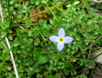
Viola macloskeyi ssp. Pallens, northern white violet
Pteridophytes (Ferns)
Cystopteris fragilis, fragile fern
Dennstaedtia punctilobula, hay-scented fern
Osmundastrum cinnamomea, cinnamon fern
Thelypteris palustris, eastern marsh fern