Winter Rally Re-Cap
We were so delighted to host the first ever Mount Rogers Winter Naturalist Rally this past weekend!
We were delighted to host the first ever Mount Rogers Winter Naturalist Rally last weekend! It has been one of our objectives to host a fall, winter, and summer rally. The winter rally focused on the flora, fauna, weather, and terrain that is unique to the cold, winter months! 80 eager individuals experienced stimulating outdoor activities and great food. Our programs included winter astronomy, the Oral History of Konnarock, a weather balloon launch, a geology road trip, waterfowl prowl, wildlife tracks & signs, winter tree identification, the challenges of measuring snow, ecology & management of high elevation communities and clay bowl making with Grim Pottery.
We would like to say thank you to our keynote speaker and guide, Dr. Doug Miller, for his extraordinary presentation, “Sandy Snow: An Unusual Hurricane Winter Wonderland”. We would also like to thank our incredible guides that really helped make our first Winter Rally a success. Thank you to Allen Boynton, Cade Campbell, Jeremy Stout, Dr. Ed Davis, Mark Archibald, Arthur Merschat, Jordon Blevins, and Debbie Yates.
Kids programs were lead by Program Coordinator Ali Reilly and Naturalist Educator Olivia Jackson. Fries School brought 18 students to explore the Blue Ridge through programs such as intro to birding, geology, tracks & signs, snow science, and winter ecology.
Finally, a special shoutout to our spectacular volunteers, the BRDC Board! Their help truly allowed the rally to run smoothly and efficiently.
We can’t wait to see everyone back on our campus for our Spring Rally coming May 12-14! Stay tuned for more updates!
The Blue Ridge: A Geological Autobiography
If the Blue Ridge could write its own long and complex history, surely it would chisel the words in stone. Fortunately, it did just that. And fortunately, we have a translator in our midst. During our January 2019 Geology Expedition, USGS Geologist Arthur Merschat unraveled the story of the geologic events that left Virginia’s oldest basement rocks exposed for us to access and admire.
If the Blue Ridge could write its own long and complex history, surely it would chisel the words in stone. Fortunately, it did just that. And fortunately, we have a translator in our midst. During our January 2019 Geology Expedition, USGS Geologist Dr. Arthur Merschat unraveled the story of the geologic events that left Virginia’s oldest basement rocks exposed for us to access and admire.
The Blue Ridge Mountains as we see them today are a result of several major geologic events. Initially, tectonic plates drifting together over time caused continental collisions during the Grenville orogeny and produced the supercontinent Rodinia around 1 billion years ago. Around 750 million years ago, Rodinia began to break up and caused a series of lava flows and volcanic eruptions. The final breakup resulted in the pulling apart of the continent and the formation of oceans, and for a time, Virginia existed as a tropical marine environment located south of the equator. Evidence of this can be seen in the fluvial to marine sedimentary rocks of the Chilhowie Group along Whitetop Rd. However, during the Alleghenian orogeny 300 million years ago, Africa collided with us to form the supercontinent Pangea. This event thrust billion-year-old basement rocks and 750 million-year-old volcanic rocks of Mount Rogers above the layered rocks of the Valley & Ridge. It is these ancient, metamorphosed rocks that we encountered on our trip.
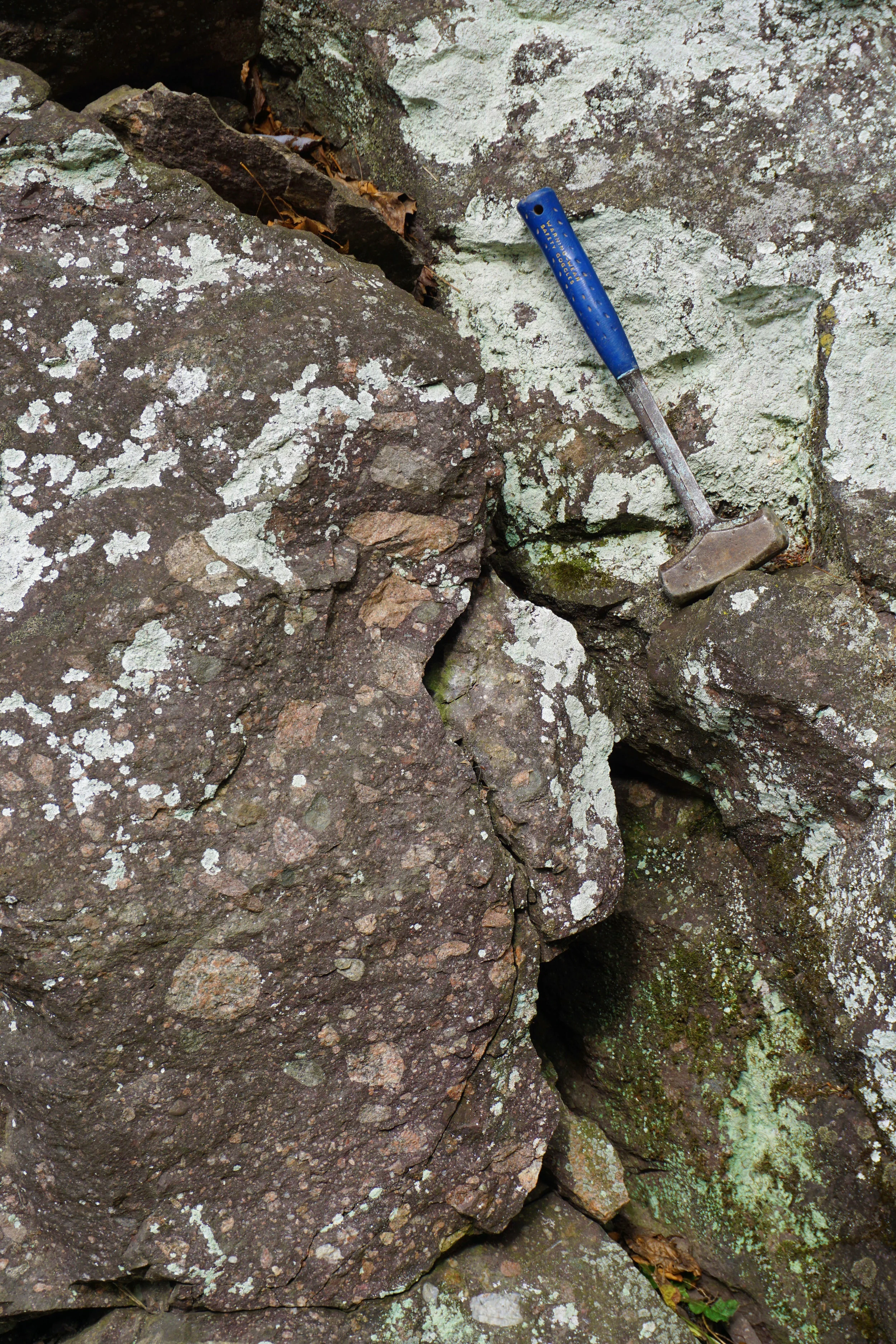
The trip began with a visit to a road cut of 750 Ma diamictite (pictured) within the Konnarock Formation. This sedimentary rock consists of clasts (pieces of rock or minerals that range from pebbles to cobbles and boulders) supported by a matrix of sand and clay and tells us that this area was once a glacial environment.
Our next stop within the Konnarock Formation provided an opportunity to spot dropstones. During glacial melt, granite stones that had been carried in the ice dropped into the soft sediment (rhythmite and laminite) of the lake beds.
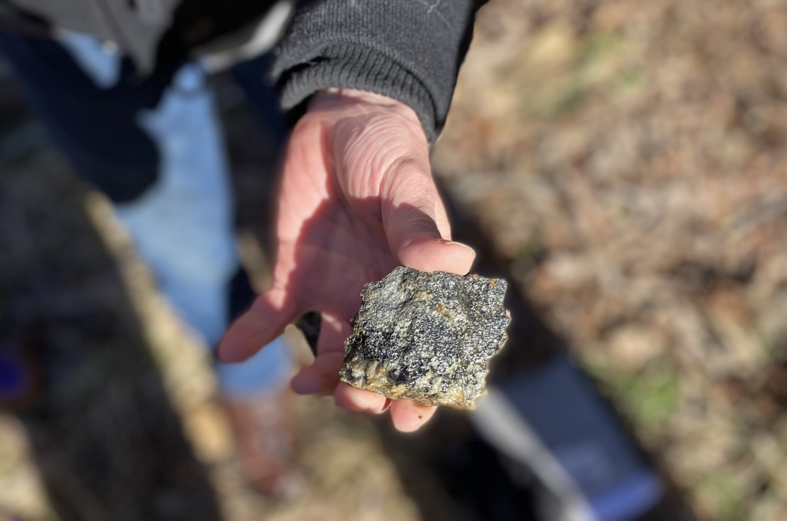
Next, we ventured north on Whitetop Rd. to view elements of the Unicoi Formation within the Chilhowie Group, where a 540 Ma basalt flow is easily visible within a road cut on Iron Mountain. From north to south it is possible to see the basalt flow with conglomerate, arkose, and shale below, and quartzite above. During metamorphism, vesicles - former gas bubbles within the volcanic rock (basalt) - were filled with other minerals such as potassium feldspar and calcite. These filled vesicles are referred to as amygdules (pictured).
Our next stop was the Hampton Formation at Skulls Gap on Whitetop Rd. Here, an underwater landslide occurred while the black shale (formed in an anoxic environment) and sandstones were deposited, which were later metamorphosed into slate and quartzite (pictured).
Heading across Whitetop Mountain and along the Stone Mountain Fault, several stops allowed us to view rocks within the Mount Rogers volcanic center, including flow-banded lava, arkose, and volcanic breccia, as well as greenstone featuring phenocrysts of plagioclase (large, conspicuous crystals of plagioclase feldspar), and more amygdules, this time filled by epidote and quartz. Next, we encountered the Buzzard Rock member, the lowest and oldest rhyolite in the Mount Rogers volcanic center at over 755 million years old.
Once we crossed over the Catface Fault into the Pond Mountain volcanic center, we encountered mylonite, a fine-grained fault rock containing muscovite which had been lineated due to shearing and flattening.
Farther up the road, we glimpsed a peek at the 1.1 billion-year-old basement rocks within the Stone Mountain thrust sheet. These coarse, whitish-gray and pink granite rocks contain minerals that were crystalized deep in the earth’s crust before the formation of the Blue Ridge Mountains.
Our final stop at a road cut afforded us a wide view of the large clasts of rhyolite, granite, and arkose that comprise this boulder conglomerate. Beautiful!
The Geology Expedition was a full-day adventure of traveling through and unraveling millions of years of the Blue Ridge’s history. And although we only encountered a fraction of what there is to see, we ultimately acquired a deeper understanding of the geologic events that created this montane region*, the very foundation of our Center.
*If you are interested in learning more about the natural history of this unique region, join us for the Spring Mt. Rogers Naturalist Rally May 10-12, 2019.
Members FREE, Non-members $10
Trip Photo Gallery
A Week of Discovery
Thirteen kids joined BRDC at Matthews State Forest Pavilion for Discovery Day Camp.
Geology, birds, butterflies, cartography, stream ecology, primitive pottery interspersed with arts, crafts and hands-on activities filled our week. Thirteen kids joined BRDC at Matthews State Forest Pavilion for Discovery Day Camp.
On Monday, we learned about types of rocks and the rock cycle, minerals and crystals. Using play-dogh and sugar, the kids created examples of sedimentary, igneous and metamorphic rocks and crystals from sugar. Later in the day, they examined a local map and then created a treasure map and found the hidden treasure from their maps.
The interns from Matthews State Forest took the kids on a hike around the property on Tuesday finding leaves to create a "Book of Trees". They put their hands into the Mystery Box and tried to identify the objects found inside. We later found seeds, nuts and fruits of trees and played games.
Wednesday was primitive cultures and tracks and signs. They created pinch, coil and slab pots out of clay and later expressed their artistic talents painting these creations. We played a game focused around information gathered from tracks and then created tracks of animals of the Blue Ridge. In the afternoon, we hiked to find tracks of animals and made casts of these tracks.
Thursday continued our adventures with birds and butterflies. After basic binocular use, we explored the Forest for as many species of birds as we could find. They found fifteen species of birds! After collecting materials that would be used for nests, the kids built nests and played games such as Migration, Bird Beak and had paper airplane contests. These games emphasized adaptations, basic needs, and physics of bird flight. During the afternoon, we caught Silver-spotted skippers and Common buckeye butterflies.
Friday was a day of playing and exploring in a creek. After scouring the bottom and rocks for aquatic insects, crawfish and fishes, they spent the remainder of the day splashing around. What a great week of discovery and sharing. A special thank you goes out to Matthews State Forest for allowing us to utilize this great property to explore, discover and share the wonders of the Blue Ridge!
Young Explorers turn their attention to the rocks and may never look back!
Geology is literally at the foundation of everything having to do with Natural History, the root of it all, but even beyond that, there is the spectacular emotion that comes over a person when they spot a shiny speck in the dirt that might be a crystal. These two powerful draws pulled the Young Explorers out into the field on Saturday November 21, 2015 for a day of rockhounding, history lessons and exploration.
The day started at 9am with 8 kids and 4 adults headed west towards Saltville. Our first stop was along route 603 at a road cut along Fox Creek Falls. In that cut we could see a dense conglomerate that represented a fast flowing stream much like the current Fox Creek. You can clearly see the rounded rocks touching one another to indicate the tumultuous flowing water. With closer inspection one can study the layout of the individual stones in the conglomerate and identify the direction of water flow.
The next stop was also along 603 where we had clear views of still-water sedimentary rock where one could observe the very distinct layers that defined varying seasons of silt and speed of erosion. Circular scars in the form of bore holes were left by geologists at both sites and made the kids jealous that they could not retrieve such perfect samples of geologic history.
Our third stop took us to a site that none of us had ever visited, just across I-81. It was a small limestone quarry in the valley along highway 107. With eyes peeled for fossils the group quickly realized that the quarry held a wealth of tiny crystals and set their sights on scouring the crushed stone for dolomite and quartz vugs. One very spectacular specimen sparkled amidst the limestone: a small quartz crystal that is referred to as a "Saltville Diamond". Even at just 6 millimeters in diameter it's beauty shone like an engagement ring in contrast to the limestone and dolomite it was perched on. We also found multiple curious formations in the limestone that tell a distinct geologic story...
From there we headed over to The Museum of the Middle Appalachians in Saltville, VA where we intended to study their impressive local geologic and ice age mammal displays. Instead we ended up talking with their curator almost entirely about the history of Saltville and the importance of salt to humans. Mildly disappointed on the focus and a bit behind schedule we left the Museum and headed west to "The Great Channels of Virginia". Although the curator drew us a treasure map for a local fossil collecting site we had to skip over the site to begin our strenuous 6 mile round trip hike before the day got any further along.
After a quick lunch in the route 80 trailhead parking lot, we gathered our explorer packs and set off on foot towards the Great Channels. This fascinating geological feature is part of a State Natural Area Preserve that encompasses 721 acres around Middle Knob on Clinch Mountain. The peak of which caps out at just over 4,200ft and hosts a fire tower as a beacon for the destination. Geologists speculate that the 400 million year old sandstone formation was cracked to its current state during the last ice age when the power of ice wedged the rocks apart to create the channels.
The hike to the top gave us clear alternating views of the Blue Ridge's Mount Rogers and Whitetop Mountain in the Southeast and the 4,600ft evergreen cap of Beartown Mountain to the Northeast with the West Virginia coal laden mountains off to the far north. The trail spanned millions of years of geologic record with layers and layers of sandstone rocks as we climbed to the top. One particular section held a mass of fossil deposits including Trilobites.
At about 3,800ft in elevation the forest dramatically changed to a rhododendron understory and the harder sandstone formations began their presence along the trail cut.
As the trail leveled out and the destination came into reach, the kids (and adults) picked up the pace and excitement. We arrived at the peak and fire tower, a little bit confused about what and where the Channels were but eager to seek out the reason we had made the journey. After a short inspection we found a sign that pointed the way.
Of all things that can influence one's emotion, perhaps a dramatic change in space is the most powerful. The wonderment of a new spectrum of senses will heighten your attention to detail and bring on a wave of excitement like no other. In the case of the The Great Channels that change could not be more dramatic. One goes from a vast windswept and sun-bleached peak where the ruins of a shelter bare evidence of brutal exposure... to the flip opposite: a series of crevices that feel as cozy and protected as a hobbit hut.
The light switches from the glaring bright white of a clear November day to a soft ambient sandy glow filtered by 40' tall moss lined walls. You go from being a speck in a near endless Appalachian vista to being a wedge between rock walls that are sanding holes through your pack as you explore deeper. Your steps echo through the seemingly hollow white-sand and moss-lined bottoms of the crevices. The wind may be howling above at 40mph but you would never know it inside of the Channels. The air is still, humid and cool but not cold. The rocks are cold, and damp to the touch, but with the ever-present texture of 80 grit sandpaper. The walls are a surface of endless undulations and soft curves that beckon you along the path. Around each corner lies another irresistible dark crack with soft light glowing at end. The few trees that have taken root in the Channels climb straight as arrows to the window of light above . You have to brace yourself between the rocks to tilt your head back far enough to find that same light. The sounds are all still, quiet and reflective, except the occasional "WOW! you've got to check this out" echoing from around the corner, but which corner? It is a maze of channels that feels like it repeats endlessly but uniquely at the same time. It is a wonderment everyone should experience sooner rather than later.
Running out of daylight we had to cut our exploration of the channels short at just 45 minutes and reverse course to avoid hiking in the dark. With such a short trip this adventure just cracked the door of our curiosity about the Great Channels. We will be back to answer the many questions aroused by the hike. The explorers in us stood on the edge of the steep ridge looking west, longing to continue the adventure into the ridges and valleys before us but alas we must turn around and refocus our attention on the yet unexplored coves of our homeland: The Blue Ridge.
The hardy group made the chilly trek back to the cars, arriving just as darkness set in at about 5:45pm. The parking lot resolution was that we needed sustenance! The drowsy caravan headed east to Marion and 27 Lions where Mrs. Benish treated us all to brick-fired pizza and coca-cola! After twelve hours in the field this impressive group of explorers put another notch in their belt with this bond forming western quest to the Great Channels of Virginia.
Blue Ridge Expeditions: The Channels, Clinch Mountain
One of southwest Virginia’s most spectacular and unusual natural preserves will be explored on this Blue Ridge Expeditions (BRE) hike. The part of Clinch Mountain known as The Channels is an area of huge sandstone rock outcroppings where ancient forces have created a maze of giant fissures, some of which now serve as passageways somewhat similar to slot canyons of the western states.
Leaders: Roald Kirby and Fred Newcomb
One of southwest Virginia’s most spectacular and unusual natural preserves will be explored on this Blue Ridge Expeditions (BRE) hike which is sponsored by the Blue Ridge Discovery Center (BRDC). The part of Clinch Mountain known as The Channels is an area of huge sandstone rock outcroppings where ancient forces have created a maze of giant fissures, some of which now serve as passageways somewhat similar to slot canyons of the western states.
The hike will be a 5 mile round trip of moderate difficulty and will take place on Sunday, July 27. Geology expert Fred Newcomb and Roald Kirby will lead the group. Participants should call (276) 579-4011 to register and for more information.
Flat Rock Church, Striped Granite
Flat Rock Church, October 2, 2010
What is this rock, and why is it here?
Over twenty people
from the Flat Rock community and the Independence Methodist Church attended yesterday evening’s geology program presented by Fred Newcomb, and hosted by Blue Ridge Discover Center. Fred has taught middle and high school students geology and earth history for 33 years. Before that he was employed as a petroleum geologist for several major oil companies and worked in North Africa and Southeast Asia. He and his wife, Beth (also a teacher), live in Grayson County.
Fred began his program
at 4:00 PM, setting up outside under a grove of trees. Flat Rock Church and community center are built upon a large outcropping of granite, which gave rise to the inspiration to share some deep history of this unique place. Along with two tables of rocks and other demonstration tools, Fred also handed out printed material to help illustrate the content of his discussion.
Beginning with some basic rock identification
, Fred drew our attention to the composition of granite in general, and the striped granite on site specifically. From there he took us back in time, explaining the theory of plate tectonics, origin of the continents, radiometric age dating and eventually pulled us back to the moment and the rock we were sitting on. During the hour and half, he entertained many good questions, explained things with uncanny clarity, and took time afterwards to help identify rocks that some of the community had brought to share.
As the bright autumn sun
gave way to brisk breezes, a fire was built and a hot dog roast initiated. Before I departed, one elder member of the community asked me if we could do an astronomy program some day, to which I replied, certainly.
-Scott Jackson-Ricketts
Exploring Grindstone
This forest chews lava, and exhales the whispers of glaciers...
Sipping from rock once fuming and flowing
Drawing from deep water pebble-pimpled silt,
Splitting muck-mired cobbles of glacial mowings
Benefacting cycles of rise and wilt...
This forest
chews
lava,
and
exha
les
the
whispers
of
gla
ciers...
-D. Floyd
On Sunday the 12th,
a mother, a father, and a son explored the forest at Grindstone Campground on the north side of Mount Rogers. We were there to 'see what we could see'. Our walk took us around the short Grindstone loop trail, the 'Whispering Waters nature trail'. As has been experienced in the past, the beauty is blinding and the diversity overwhelming. One passes through at least two distinct forest types and transitions from glacial lake deposits to lava flow remains.
The forest along the upper portion of the trail is truly unique, as it is dominated by linden, ash, and cucumber magnolia. The great number of seeps along the trail provide for excellent exploration and the make-up of the forest shifts around every corner!
Here's a small bit of what we saw:
Geology:
Rock type #1, near the beginning of the trail, is :
Konnarock Formation
;
Maroon diamictite, rhythmite, and arkose.
These are rocks that were deposited in habitats that included deep icy lakes and glacial activity. They are the silicified (fancy word for 'turned into rock') remains of muds, silts, pebbles and cobbles carried by glaciers. Interestingly, the stones seen in the silicified mud were dropped into that muck and consist of materials from formations nearby...ryholites, greenstones, and granites. This makes sense because the glaciers would have been eroding these materials from the land during that time...and, it was a landscape devoid of plants and animals!...mountains and valleys of pure rock, silt, and sand!
Rock type #2, as one heads up the trail the rocks change to:
Mount Rogers Formation;
Phenocryst-poor rhyolite.
These rocks are a dark purple, and are the results of lava flows! Mount Rogers, White Top, and Pond Mtn. (NC) form the core of what was a massive and explosive volcanic complex. These once towering volcanoes have seen a lot of erosion, and have even found themselves buried beneath miles of sediment at different points in the geologic past. But today, we are afforded a view of these ancient volcanoes. It is worth noting here that this rock known as "Rhyolite" is high in silica, and breaks kind of like glass (chonchoidal fracture). This made it a choice material for use in making spears, knives, and other tools during prehistoric times. Somewhere on these mountains hides ancient quarries used by Native Americans!
Primary source:
Virginia Division of Mineral Resources, 1993, Geologic Map of Virginia.
Trees and shrubs:
chestnut oak,
Quercus prinus
northern red oak
,
Quercus rubra
red maple,
Acer rubrum
sugar maple,
Acer saccharum
striped m
aple,
Acer pensylvanicum
black cherry,
Prunus serotina
yellow birch,
Betula alleghaniensis
black birch,
Betula lenta
American beech,
Fagus grandifolia
Fraser magnolia,
Magnolia fraseri
cucumber magnolia
,
Magnolia acuminata
witchhazel
,
Hamamelis virginiana
viburnum
sp.
yellow buckeye,
Aesculus flava
green ash,
Fraxinus pennsylvanica
white ash
,
Fraxinus americana
American linden,
Tilia americana
rhododendron
sp.
yellow poplar
,
Liriodendron tulipifera
eastern hemlock,
Tsuga canadensis
...and, maybe
Carolina Hemlock
,
Tsuga caroliniana
(need to revisit the site to verify)
Scientific name reference:
Two unidentified species of the Lycopodiaceae family.
Smaller plants:
ramps,
Allium tricoccum
white baneberry,
Actaea pachypoda
Solomon's seal,
Polygonatum sp.
false Solomon's seal,
Smilacina racemosa
Pipsissewa
,
Chimaphila maculata
Dutchmans pipe,
Aristolochia macrophylla
ground cedar,
Lycopodium sp.
clubmoss
,
Huperzia sp.
partridge Berry,
Mitchella repens
white snakeroot
,
Ageratina altissima
black cohosh,
Actaea racemosa (syn. Cimicifuga r.)
blue cohosh,
Caulophyllum thalictroides
yellow mandarin,
Disporum lanuginosum
jack in the pulpit
,
Arisaema triphyllum
Curtis's goldenrod
,
Solidago curtisii
**
Two aster species remain unidentified, see images below.
**Two Lycopodiaceae species remain unidentified. see image above.
My identification sources:
Newcomb's Wildflower Guide, by Lawrence Newcomb
On the way home
we could not resist stopping to take in a phenomenal meadow. Willows, hawthorns, alders, cinnamon ferns, golden rods, ironweeds, ladies' tresses and butterflies galore. This little boggy area is very close to Grindstone Campground and can be thoroughly enjoyed from the road. I suspect there are many locations in the Grayson highlands area that are similar to this one, as it is maintained as pasture.